Follow the triumphs and tribulations of a passionate genealogist.
Saturday, August 17, 2024
Making the Most of Maps
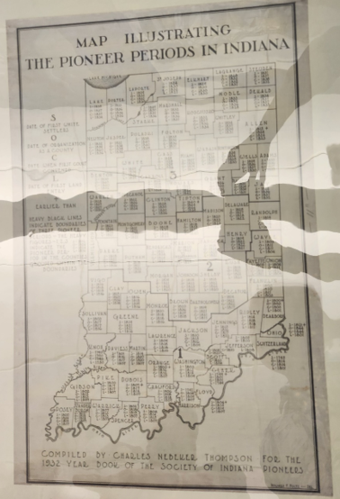
Photo taken at Indiana Historical Society by Lori Samuelson
I came upon this map when I visited the Indiana Historical Society in Indianapolis in July with the Society of Indiana Pioneers (SIP). The map was devised by SIP in 1932 to assist potential members with locating their ancestor's county's founding between 1790 and 1844. Indiana became a state in 1816 but had become part of the U.S.'s Northwest Territory in 1787. After statehood, as the population rose and scattered, larger counties were made into smaller ones. The pioneer settlement period in Indiana ended in 1849 so this map noted most of those changes.
Here's a recommendation if you find a unique map either in person or online - look for another. I realize my photo is a tad hard to read but under each county there is a code of "S, O, C, L." What does that mean?
I searched online and found the identical map with notations that explained it: S was the date of the first white settler, O was the Date of Organization, C means the first Count Occurred, and L is the first Land Entry. The codes and a blow up of the map is available online here.
Maps are an important part of genealogy. Checking to see if the resource is widely available can help you get the most out of your research.


No comments:
Post a Comment